
August 17, 2022
How a Real Estate Company Saves Lakhs of Rupees in Excavation Contract Management using Skylark’s Drone Data

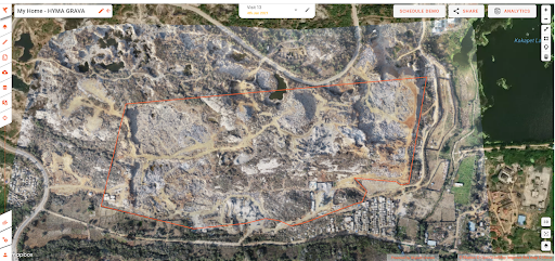
In Hyderabad, one of India's fastest expanding cities, My Home Constructions is a renowned property developer. Over the last three decades, My Home Constructions has completed 21 residential and commercial projects totaling 26 million square feet. With over 11 million square feet of building projects underway and more on the horizon. Thought leaders within the organization, such as M.K.R. Sai, president of My Home, wanted to use technology to not just meet, but exceed project excellence. In order to oversee and manage excavation contractors across two projects totaling 3.92 million square feet of built-up space spanning 5 acres and 80 acres, respectively, My Home Group collaborated with Skylark Drones.
Business Use Case
Excavation costs make up about 15% of the total project cost because hard rock can be found in cities like Hyderabad. Typically, contractors are used to assisting with the excavation.
The amount of material moved determines how much the earth-excavation contractors are paid. Therefore, it's important to measure the excavation quantities accurately. Highly accurate drone data reduces the margin of error in these calculations and the payments.
Challenges of traditional survey methods
A thorough examination of the geographical qualities above and below the ground forms the first step in the overall construction procedure. This study is one of the most important elements to determine the nature and scope of civil work, as well as to estimate the budget and timeline of the project.
Standard data collection methods using Total Station and representation of data in 2-D CAD models present a challenge as they fall short in two crucial aspects:
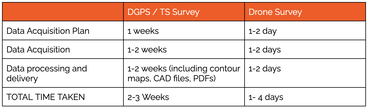
1. The time and resources required to obtain data:
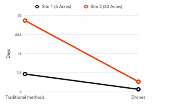
Total Station or any ground-based survey techniques take anywhere between 7 (for the 5-acre site) and 28 days (for the 80-acre site) to collect and process the data. Contractors operate considerably more quickly than this. Therefore, no information is available to approve and disburse funds right away.
2. The accuracy, reliability, and usability of data:
The typical outputs of a traditional survey: 2-D point and line diagrams fall short of portraying the actual work done, and frequent conflicts over claimed vs reported work done by contractors result in delays and management overheads such as recurrent site visits.
Goals achieved with Drone Solution
(A) Reduced data collection to report generation turnaround time by 70-80%
Drone data is collected, and processed and the accurate excavation volumes are reported in 1 day for the 5-acre site as compared to 7 days and 4 days for the 80- acre site as compared to 21 days.
(B) Reduced contractor management overhead
To build and deliver web-based drone data visualization tools to visualize worksites and dynamically generate reports near real-time w/o scope for dispute about the quality and quantum of work done.
(C) Accurate soil layer wise excavated volume
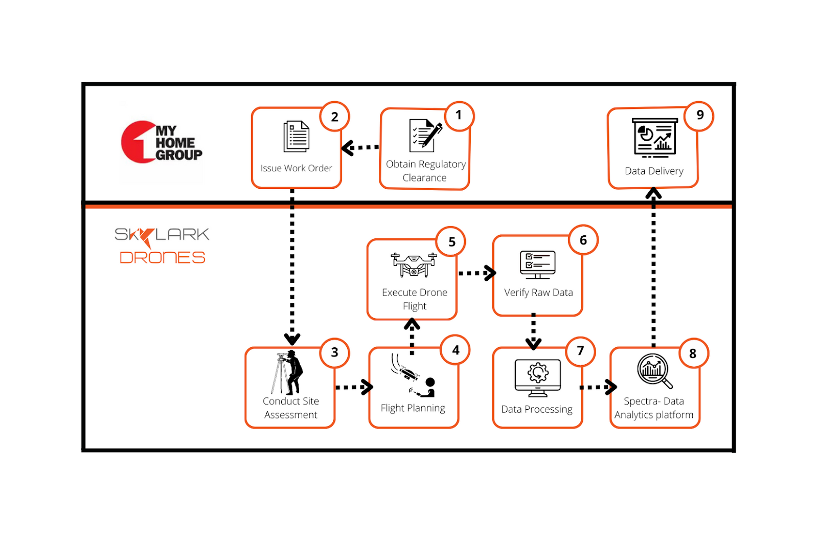
Together with solution architects from Skylark Drones, on-site engineers and project managers from My Home Group developed a workflow to gather and analyze drone data monthly over two locations for three months.
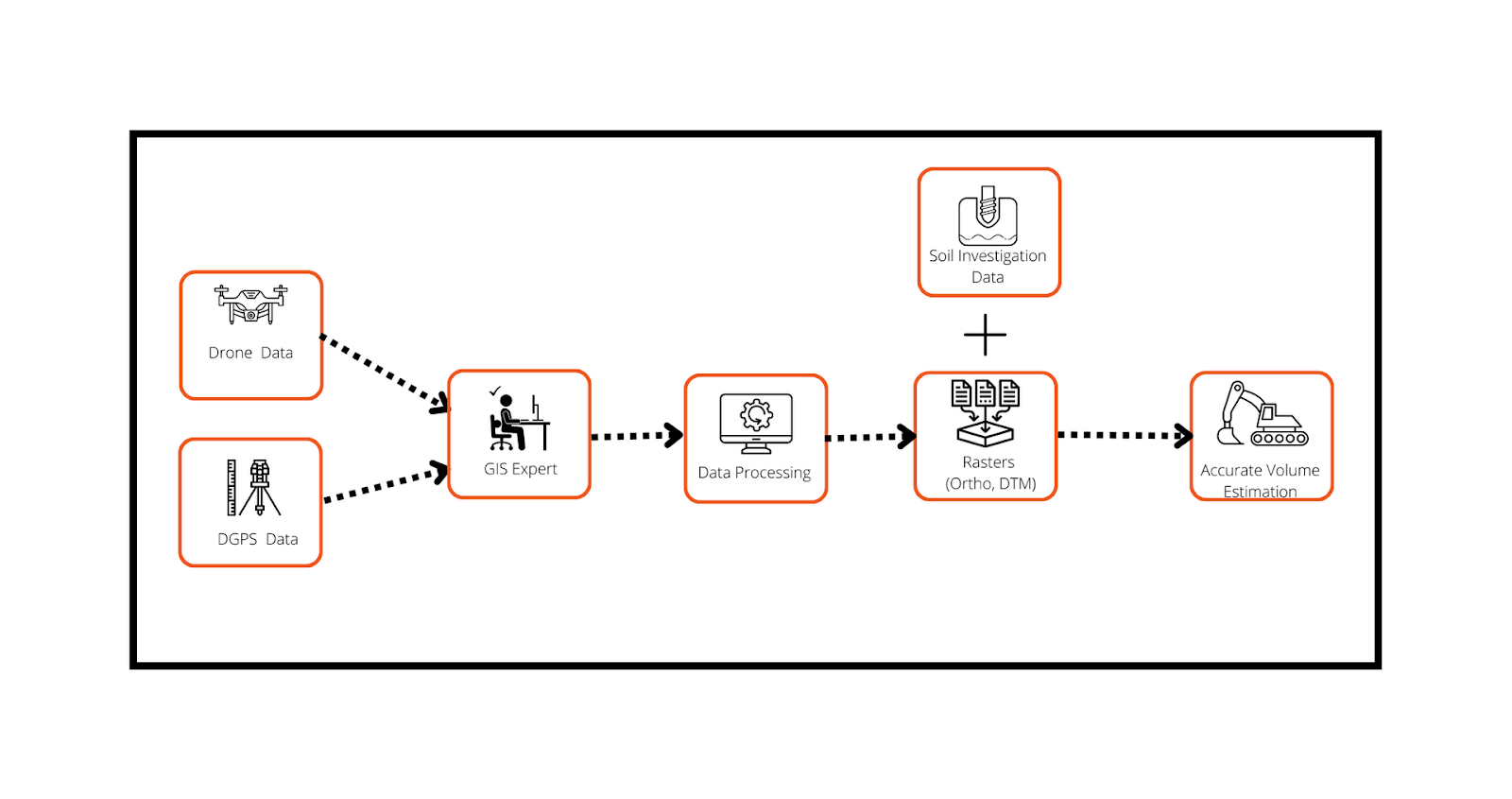
Soil layer-wise excavation volume is one of the most important and unique insights that a Drone survey can give. Unlike the traditional survey method drone survey collects high-resolution data with an accuracy of up to 5cms. GIS Experts at Skylark create a digital twin of the site, which allows them to estimate the cut-fill volume and measure every inch of the site with utmost accuracy.
Methodology employed to achieve these goals
Skylark provides end-to-end cloud-based solutions, with its cutting-edge technology, Drone Missions Ops and Spectra. These products along with our team of experts allow us to plan, verify, process and visualize Drone Datasets with accuracy and help Skylark reduce data collection to report generation turnaround time by 70-80%. A Drone survey from data collection to reporting generation takes only 4 days for a site of 80 acres of area. Whereas on the other hand, a typical traditional survey of 80acres site, takes about 21 days to complete.
In order to successfully complete the survey, the methodology below is adopted by the stakeholders:
To achieve accurate total and soil layer-wise volume measurements our team first conducted a drone survey with strategically placed GCPs of the site. After verification and performing photogrammetric processing of the raw dataset, the outputs are:
- Orthomosaic: with accuracy up to 5cm, any observations (or measurement)extremely precise.
- Point Cloud: allows the user to make observations (and measurements) about an object’s depth, elevation, geometry, and location in space. Since every point cloud is capturing unique physical attributes, all point clouds look different from one another and they come in all shapes and sizes.
- Digital Surface Model (DSM): is an elevation model produced from an extremely dense point cloud that captures the measurements of all entities present in the site (including all the man-made and natural features).
- Digital Terrain Model (DTM): is an elevation model produced after cleaning the elevation building, tall trees, and any other feature except the bare ground elevation values from the DSM. This DTM is used to perform any further calculations over the raster, such as total volumes and soil type-wise volumes.
These photogrammetric outputs are then used by Skylark’s platform Spectra to perform various GIS analyses. Spectra’s cut-fill volume tool calculates accurate volume. Comparison of these estimations with the previous survey give the decisionmaker the sense of progress that the contractor is making.
Skylark’s in-house experts employed the methodology below to achieve accurate volume estimations:
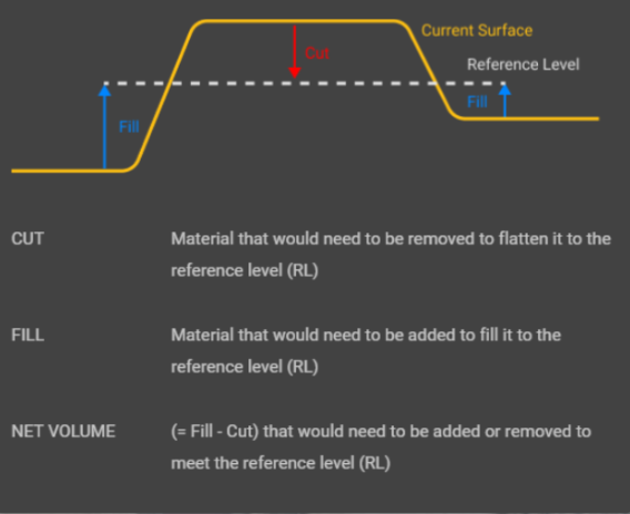
Spectra’s volume tool performs two different types of Volume calculations to help My Home constructions with Contractor Management:
- Compare volume: This tool helps calculate the cut-fill volume between the current survey and a previous survey.
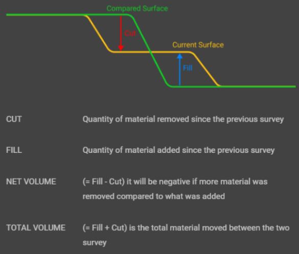
- Reference level Volume: This tool helps calculate the volume between the current surface and the reference level. The reference level is an input given by the user, in this case, reference level values are nothing but the depth of each soil layer that a soil investigation using a bore hole produces. This tool helps the user with accurate soil layer-wise volume calculation.
The different soil types that existed on this particular site of My Home are:
- Silty soil
- Silty gravel
- Gravel
- Silty sand
- Hard Rock
Every soil type has different properties, some being coarser than others. The excavation plan, equipment, and manpower requirements also vary accordingly. For example, the top layers are soft and can be easily excavated whereas the rocky layers would essentially require heavy machinery and sometimes dynamite blasting to loosen up the soil. Spectra’s volumetric report not only gives a clear picture of the progress on the excavation on the site but also helps the site manager to plan better.
Digitization of My Home worksite
To replicate ground reality to the nearest inch, a geospatial digital twin of the My Home construction sites was developed.
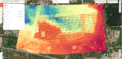
These raster are also visible in 3D in Spectra. As 3D site models are so easy to view and understand, the data is easy to share. 3D modeling helps provide reports to external stakeholders like clients or subcontractors, demonstrating that work is on target for any relevant deadlines and letting them see the in-progress worksite without requiring a visit.
This particular site of My Home is divided into a few different sections. Each of these sections has an estimated depth to which soil must be excavated for the construction team to start building the base of the building.
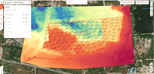
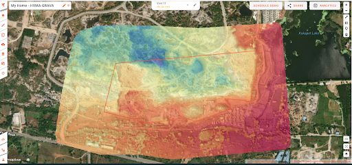
Extracting temporal and geospatial insights
Blue indicates the regions where the contractor has progressed and Red indicates the regions where contractor work has not progressed.
Impact Created by the Use of Drones Technology
(A) Reduction of data collection to report generation turnaround time
(B) Reduction of contractor management overhead in terms of time saved
M.K.R Sai, President, My Home Group says “Drone based solutions from Skylark Drones helped us monitor and measure the quality and quantity of work done regardless of the size of the worksite. Drone data, in particular, was crucial to getting all teams on the same page and cutting down on the time and effort to manage contractors remotely.”
Going Forward
“At My Home we wanted to leverage technology to cut down on time and cost overruns in the most critical aspects of our management workflows and I believe drones will become a common sight in the mainstream construction industry in the years to come, it is only a matter of validation and eventual adoption.” - M.K.R Sai
Conclusion
My home construction builds residential high-rise buildings. To build a strong base for these buildings, excavation is planned. Excavation costs alone make up about 15%of the total project cost because hard rock can be found in cities like Hyderabad. Typically, contractors are used to assisting with the excavation process. The amount of material moved determines how much earth-excavation contractors are paid. This is the reason why My home construction would require an accurate estimate of total excavation along with soil layer-wise volume estimates. These volume estimations will not only help them with vendor payments but also track the progress of their project and make better business decisions
